
-
Recent Posts
- Kuhio Beach and Ponds in November
- Life around Manhasset Bay
- Hanauma Bay for the chronically overprepared
- Kayak to Kaneohe Sandbar – sunken at high tide
- Why does my snorkel mask fog up?
- Waikiki & Honolulu landmarks seen from departing flight DL650
- Actual landing flight path of Delta 650 at JFK runway 22L
- Reign Ares as big-wheel skates for urban marathons
- What are carbon-fiber inline skates ?
- Big Wheels on Carbon Hockey Skates
- Where to Inline Skate on Long Island
- Check that your sunglasses block out all UV rays
Top Posts
- What Exactly is a Peeled Extreme Beef Tenderloin from Costco?
- Hanauma Bay for the chronically overprepared
- How to Inline Skate
- Asian-fit helmets are a lot of hot air
- Battlefield 1 Soldier Uniforms from all Factions
- What happens when you let saturated salt water dry up completely?
- Minuet 2 from Bach Cello Suite 1 (BWV 1007)
- Clean and Free Sheet Music for Bach Cello Suites
Categories
- Classical Music (16)
- Cello (11)
- Composition (6)
- Free Sheet Music (16)
- Fun (83)
- Being a Wikipedian (44)
- Drawings and Paintings (7)
- Gourmet (3)
- Hawaii (6)
- Ice Skating (4)
- Inline Skating (23)
- Photography (30)
- Travel (29)
- Planes (32)
- Flight Simulations (7)
- HHAMS (18)
- RC Planes (12)
- Real Planes (3)
- Science (11)
- Atheism (3)
- Debuking Pseudoscience (2)
- Evolution (6)
- Short Stories (3)
- 中文 (14)
- Classical Music (16)
Archives
- January 2026 (1)
- December 2025 (4)
- November 2025 (2)
- November 2024 (1)
- October 2024 (2)
- August 2024 (1)
- June 2024 (1)
- March 2024 (1)
- January 2024 (1)
- August 2022 (3)
- July 2022 (2)
- June 2022 (1)
- May 2022 (1)
- April 2022 (2)
- March 2022 (2)
- November 2021 (1)
- October 2021 (9)
- September 2021 (1)
- October 2020 (1)
- August 2020 (1)
- June 2019 (4)
- April 2019 (1)
- March 2019 (1)
- January 2019 (1)
- December 2018 (5)
- November 2018 (1)
- May 2018 (1)
- April 2018 (1)
- January 2018 (1)
- December 2017 (5)
- November 2017 (2)
- October 2017 (3)
- June 2017 (3)
- April 2017 (6)
- March 2017 (2)
- February 2017 (9)
- December 2016 (10)
- November 2016 (3)
- September 2016 (1)
- August 2016 (2)
- July 2016 (1)
- May 2016 (4)
- April 2016 (3)
- March 2016 (2)
- December 2015 (1)
- October 2015 (1)
- September 2015 (1)
- August 2015 (1)
- December 2014 (1)
- July 2013 (4)
- June 2013 (6)
- May 2012 (1)
- March 2012 (1)
- February 2012 (2)
Meta
-
-
Tag Archives: Maps
Kuhio Beach and Ponds in November

Kūhiō Beach at Waikīkī, along with its two walled ponds, is often misunderstood. It is frequently lumped together with the rest of Waikiki beaches and dismissed as eternally crowded – “like a zoo”, as they say. In reality, each beach along Waikiki Bay has its own distinct vibe, shaped by differences in location, reef structure, parking access, and proximity to oceanfront resorts.
Surfers begin gathering at Kuhio Beach well before sunrise, paddling out to Canoes, arguably the most popular surf break along all of Waikiki beaches. Long before swimmers arrive at the walled ponds, surfers are already catching waves on the reef just outside the west pond. Even after sunset, silhouettes of surfers can still be seen braving the break, moving against an ocean painted with the fading afterglow of dusk.
I don’t know what Kuhio Beach looks like in summer or during the holiday season, but I can describe what it feels like to stay beside it for a week in November. The experience was noticeably different from influencer videos that highlight midday crowds during peak months. It also felt less touristy than portrayed by websites written by people who have something to sell to you.
Posted in Being a Wikipedian, Fun, Hawaii, Travel
Tagged Hawaii, Kuhio Beach, Maps, Waikiki
Leave a comment
Life around Manhasset Bay
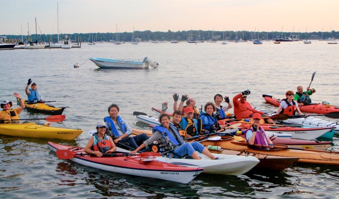
I have been taking pictures around Manhasset Bay for quite some years now. Except for a few that I uploaded to Wikimedia as an Wikipedian a decade ago, most have never seen the light of the day. I dusted off a bunch of these and re-processed them. I hope they capture a glimpse of the life around the bay that fictionally separated Jay Gatsby from Daisy Buchanan.
The truth is that many people around the bay have very little idea how their towns look from the water. And those not addicted to examining satellite pictures are often unaware of expansive waterfront properties.
Most water-fronting mansions are shielded from unwanted street views. But all of them are clearly visible from the bay, for obvious reasons. After all, if you can’t see someone’s bedroom window from a kayak, then they can’t see the water either from their bedroom.
The bay comes alive in summer. Sailboats, kayaks and all sorts of watercraft abound. Yacht clubs hold races that draw sailors from all around the bay, and often beyond.
Posted in Being a Wikipedian, Fun, Photography, Travel
Tagged Kayaking, Manhasset Bay, Maps
Leave a comment
Hanauma Bay for the chronically overprepared
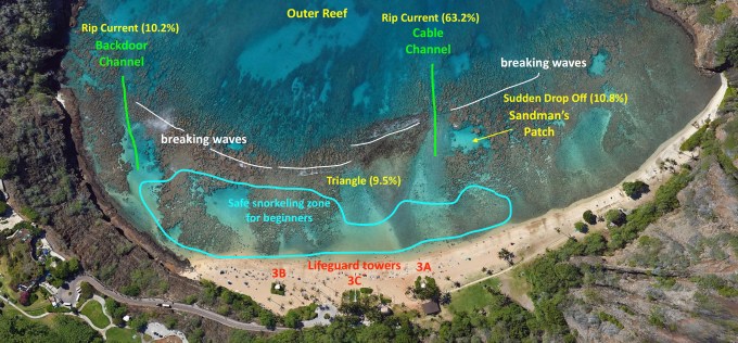 I enjoy writing about things I can’t find online. Here I wrote a snorkeling guide to Hanauma Bay for those of us that must obsessively research before our trips. I wish someone had written one before my trip. Continue reading
Posted in Being a Wikipedian, Fun, Hawaii, Travel
Tagged Hanauma Bay, Maps, snorkeling
Leave a comment
Kayak to Kaneohe Sandbar – sunken at high tide

On a windy and rainy day in November, I rented a kayak from Go Bananas, and drove to He’eia Kea Boat Harbor. I launched off towards where I thought the legendary Kaneohe Sandbar would be.
For the entire trip to the sandbar, I paddled alone in a foreboding ocean. Perhaps “bay” is a more accurate description. But from my low vantage point, it looked as if I were in the middle of the wide wide sea under dark clouds. I aimed for Kapapa Island as told. And that was good advice. Because from my kayak, all I could see were breaking waves in every direction, except for that tiny speck of an island in the distance.
I kept turning my kayak back towards the harbor, second-guessing the sanity of my choice. I saw dark clouds pouring rain over entire towns. I pivoted back towards Kapapa Island and paddled some more, all the while frightened to the core and utterly alone.
I reached the last boat in sight, hoping to find tourists having a great time. But it was empty, silent and moored in deep water. No sandbar to be seen. I swung back facing the harbor. I again turned towards Kapapa. I kept going.
After what seemed like a lifetime, I sensed a change in water color. Shortly the sun poked its head out from behind clouds. And magic happened. The sea all around me turned turquoise as soon as sunlight touched them, revealing that I was merely a foot above the sand now. I got why this place is also known as the Sunken Island. Continue reading
Waikiki & Honolulu landmarks seen from departing flight DL650

Delta 650 took off from runway 8R at Daniel K. Inouye International Airport due East at 5:15pm local time. Our pilot seemed to have made a point of banking the aircraft to trace the southern coast in the first 4 minutes of the flight to afford those seating on the left side a great aerial view of Sand Island, Honolulu downtown, Ala Moana, Waikiki, Kaimana, Diamond Head, Kahala, Hawaii Kai, Hanauma Bay, and Koko Head. Then the plane turned East again and flew towards the mainland.
Unlike the JFK arrival video I recorded, I was able to recognize all landmarks as I looked out of my window seat. This is largely due to my month-long research into Oahu before our trip to the island. But still, I figured I would write a post showing these famous Hawaiian landmarks. Here is the recorded video. Continue reading
Posted in Flight Simulations, Hawaii, Photography, Planes, Real Planes, Travel
Tagged Maps
Leave a comment
Actual landing flight path of Delta 650 at JFK runway 22L

I’ve always chosen window seats on flights whenever I could. And I never grew tired of watching my plane take off and land. Possibly I am just fascinated with flying, whether it involves model airplanes, computer simulations, or actual planes. But with only a few exceptional landmarks, I could almost never identify in realtime what the plane was flying over. It amazes me that I can’t recognize locations that should be familiar to me where I’ve driven by countless number of times.
The truth is that aerial views often looks quite different from ground views. Even though I kept thinking that I could mentally reconstruct a god’s eye view of my neighborhood, every landing proved me wrong. And my last trip was no exception. As I the plane readied itself for landing, I looked out of the window and couldn’t tell where the plane was. I put my phone against the window pane for the first time, and recorded the entire landing path.
I played the clip backward at home, and fired up Google Maps with Globe View to rotate its map to match the window view of the terrain. Painstakingly I retraced the flight path backward from runway 22L. This turned out to be the quickest way to reconstruct the landing path. In doing so, I’ve joined a bunch of nerds like Joseph Gunn who document, among other thing, flight paths. In fact, I consulted one of his blog posts on flight patterns to confirm landing paths at runway 22L. Continue reading
Posted in Being a Wikipedian, Flight Simulations, Hawaii, Planes, Real Planes, Travel
Tagged Maps
Leave a comment

